
Tracking Shipments
Container Tracking
Track ocean and air shipments with carrier milestones, vessel positions on a map, and the age of every update — so you know how fresh each one is.
12 min readLast updated
Goal
See where a container or air shipment is right now, how far along the route it has got, and how much to trust the dates you’re looking at.
Before you start
- A transport reference — a Bill of Lading or booking number for ocean, an Air Waybill number for air. Usually extracted from transport documents automatically; you can also enter it by hand.
- Transport type set to Ocean or Air. Road freight isn’t tracked.
- A shipment past draft. Drafts aren’t registered with the tracking service.
What tracking shows you
Once a shipment has a transport reference, Trackberry tracks it automatically and displays:
- An interactive map showing the route and current position
- A progress bar with departure, transshipment, and arrival points
- ETA/ETD dates with delay indicators
- A timeline of events (port calls, flight legs, customs clearance, etc.)
- Carrier and vessel/flight information
Tracking data updates automatically via webhooks and periodic polling, so you always see the latest status.
Carrier Coverage
Trackberry can follow most major container lines and air cargo carriers. The full, up-to-date list lives on the public Carriers we track page — it is refreshed every day from our tracking provider and shows what changed recently, so you can check coverage before you book.
Search it by carrier name, SCAC code (ocean) or IATA code and AWB prefix (air). If a carrier isn’t listed, the shipment still works normally — its tracking status simply shows as Untracked.
Setting Up Tracking
Ocean Shipments
To track an ocean shipment, you need a Bill of Lading (B/L) number or booking number. This is typically extracted automatically from your transport documents — but you can also enter it manually.
- Open the shipment
- Set the transport type to Ocean
- Enter or verify the B/L number in the transport reference field
- Tracking begins automatically
Trackberry registers the shipment with the tracking provider and starts fetching data. The first update usually appears within a few minutes.
Air Shipments
For air cargo, you need an Air Waybill (AWB) number.
- Open the shipment
- Set the transport type to Air
- Enter or verify the AWB number in the transport reference field
- Tracking begins automatically
Tip: If a transport document (Bill of Lading or Air Waybill) is uploaded to the shipment, Trackberry will attempt to extract the reference number automatically. You can always override it manually.
Reading the Tracking View
Once tracking data is available, a tracking panel appears on the shipment page.
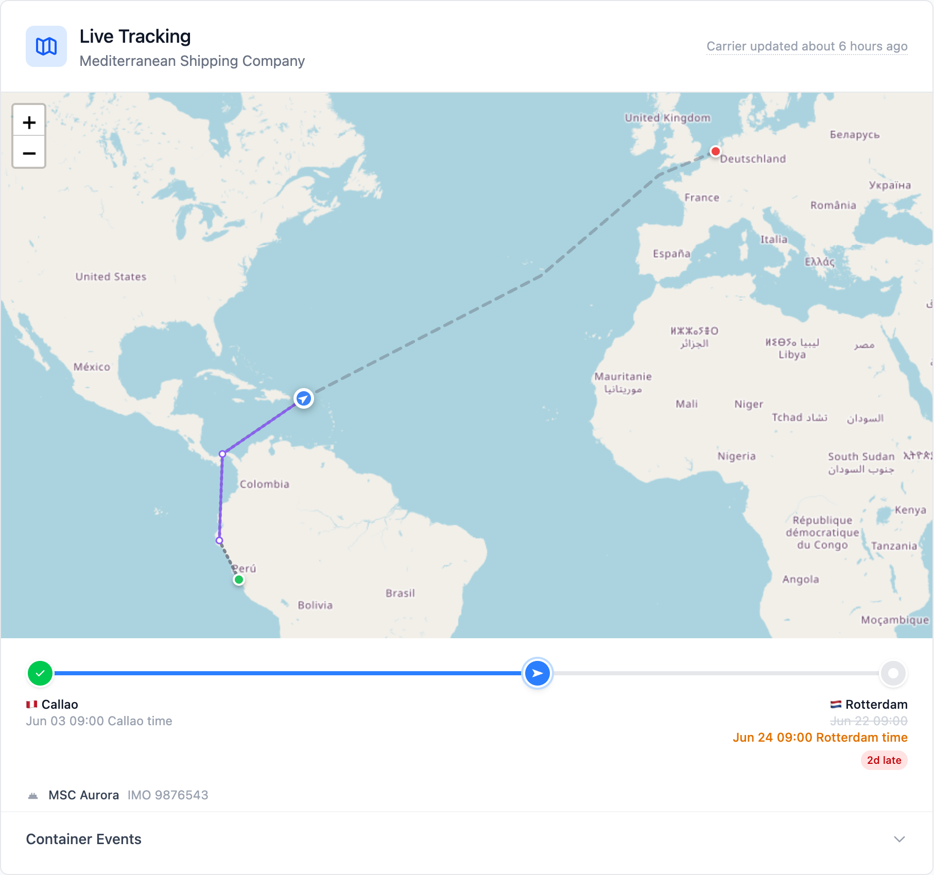
Map
The interactive map shows:
- Route segments — The path from origin to destination, including transshipment stops. It is drawn dashed because the route is the tracking service’s reconstruction of where the vessel goes. It is not a record of where it went. The stretch already covered uses a tighter dash than the stretch still to come.
- Location markers — Green for origin, amber for transshipment ports, red for destination
- Current position — A marker standing on the newest position we could confirm as a real AIS fix (ocean only). Hover it to see when the vessel was confirmed there. The marker is an arrow that points along the route, so you can see which way the vessel is heading at a glance. Positions refresh about once an hour. Each one is stamped with the time the vessel was confirmed there, so the marker shows its real age instead of pretending to be live.
- Observed track — A solid violet line joining the positions where we have seen the vessel, with a dot at each one. Hover a dot to see when we first saw the vessel there. It is the only line on the map drawn from observed positions instead of estimates, which is why it’s the only solid one.
The observed track starts when a shipment is first tracked. We don’t reconstruct positions from before then, so a shipment already at sea builds up its track over the following days instead of showing one straight away.
For ocean shipments the tracking service tells us the exact time each AIS fix was taken, and whether the container is currently aboard a tracked vessel, so only confirmed fixes are plotted. Estimates are left off the map entirely: the vessel marker stays on the last confirmed fix rather than running ahead of the track to a position nobody observed. The progress along the route still reflects the carrier’s own estimate, which is why the marker can sit behind the point where the route changes from traveled to remaining.
Consecutive fixes are joined with straight lines. Because AIS fixes now arrive about hourly, the vessel barely moves between one fix and the next, so the straight line is close to the course it sailed. We never bend the track onto the carrier’s route to make it look neater. The route is the carrier’s plan, and where the two disagree, the plan would pull the track hundreds of kilometers toward a waypoint the vessel never went near. When there is a long gap between fixes, which is rare, the line may cut across a headland. That is an accurate record of what we saw, and it’s why the dots matter as much as the line.
For ocean shipments, the route follows actual shipping lanes. For air shipments, routes are displayed as curved arcs between airports.
Progress Bar
Below the map, a progress bar shows how far along the shipment is:
- The origin (Port of Loading or departure airport) is on the left
- The destination (Port of Discharge or arrival airport) is on the right
- Any transshipment ports appear in between
- A ship or airplane icon shows the current position along the route
- Dates are shown below each stop — if the ETA has changed from the original estimate, both dates are shown with a delay badge (e.g., “2 days late” or “1 day early”)
AI-Predicted ETA
For ocean shipments, Trackberry displays an AI-predicted arrival date below the destination port when the tracking provider’s machine-learning model has generated a prediction that differs from the carrier’s official ETA.
The prediction appears as ✦ AI predicted: Jun 28 in violet beneath the ETA date. This is useful when the carrier ETA hasn’t been updated yet but vessel movement data suggests a different arrival.
The AI-predicted ETA is informational only — it reflects the tracking provider’s model output and may not match the final arrival date.
Status
The tracking status tells you where the shipment is in its journey:
| Status | Meaning |
|---|---|
| Pending | Shipment registered, not yet departed |
| Departed | Loaded and left the origin port |
| In Transit | Currently en route |
| Arrived | Reached the destination port/airport |
| Delivered | Cargo delivered to the consignee (air) |
Event Timeline
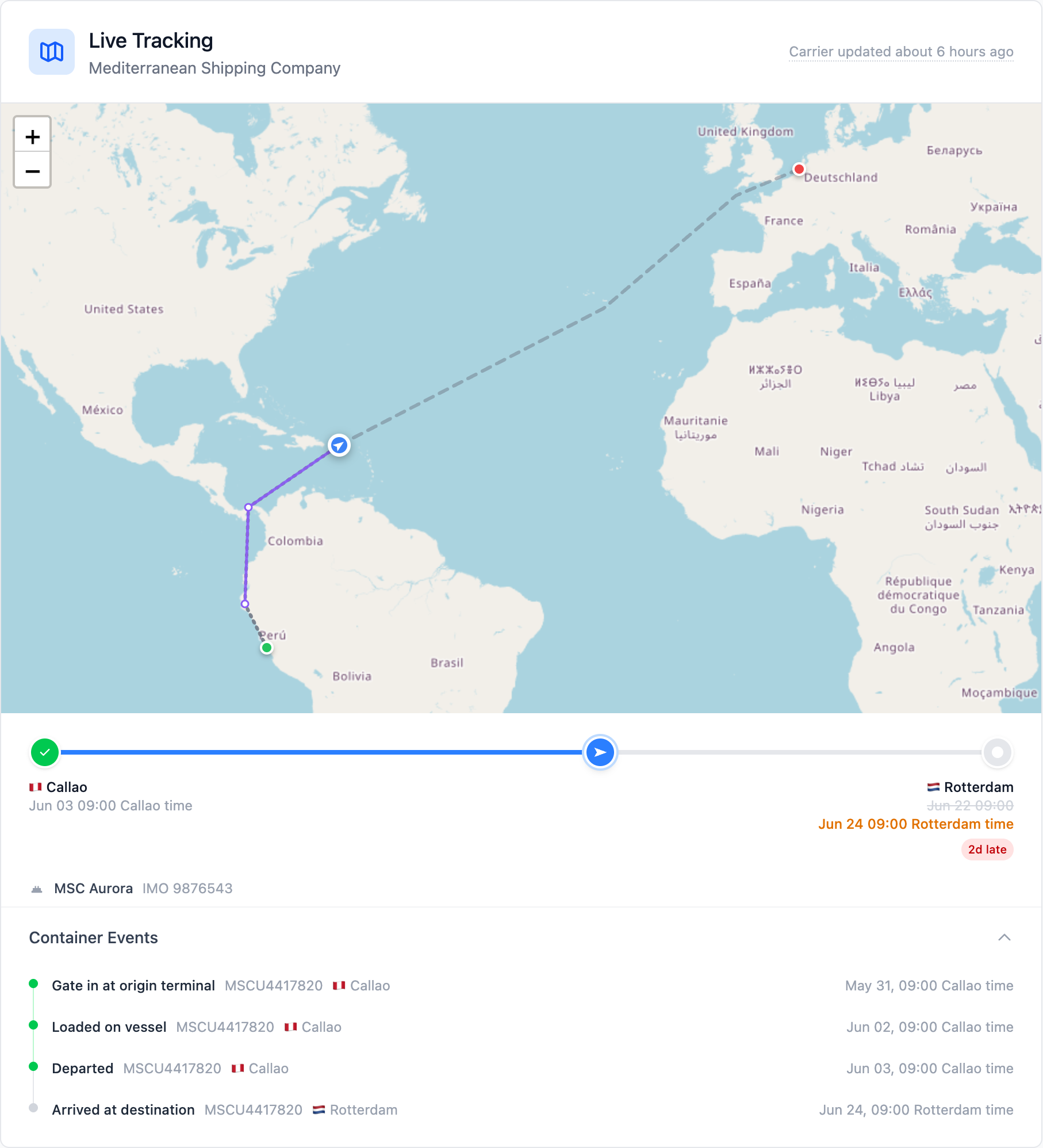
Click to expand the event timeline at the bottom of the tracking panel:
- Ocean shipments show container-level events: loaded on vessel, vessel departed, vessel arrived, discharged, gate out, etc.
- Air shipments show flight events: received from shipper, departed, arrived, customs cleared, delivered, etc.
Each event shows: - A status indicator — green for actual (confirmed), gray for estimated - The event location with a country flag - The date and time - Flight number (for air shipments)
Multi-leg Routes & Transshipments
Many shipments don’t go directly from A to B — they pass through intermediate ports or airports where cargo is transferred to another vessel or flight. Trackberry handles this automatically.
How Routes Are Built
Trackberry constructs the full route from multiple sources:
- From documents — Packing lists, phytosanitary certificates, and transport documents provide origin and destination information
- From tracking data — The tracking provider reports transshipment ports and intermediate stops
- Route reconciliation — Trackberry chains legs into the correct sequence, deduplicates overlapping segments, and fills in missing details
What You See
The route is displayed as a vertical timeline on the shipment page:
- Green dot — Origin (Port of Loading / departure airport)
- Amber dots — Transshipment ports or intermediate stops
- Red dot — Destination (Port of Discharge / arrival airport) with ETA
Each segment between stops shows: - Transport type icon (ship, plane, or truck) - Transport mode label (Ocean freight, Air freight, Road freight) - Vessel name, flight number, or truck reference - Carrier name
The header shows the total number of legs (e.g., “Route · 3 legs”).
Transport Types
A single shipment can combine different transport modes. For example, a shipment might travel by truck from the packing house to the port, then by ocean to the destination port, with a transshipment at an intermediate port:
🚛 Road — Packing house → Port of Loading
🚢 Ocean — Port of Loading → Transshipment Port
🚢 Ocean — Transshipment Port → Port of Discharge
Ocean vs Air Tracking
| Ocean | Air | |
|---|---|---|
| Reference | Bill of Lading / booking number | Air Waybill number |
| Map route | Actual shipping lanes | Great-circle arcs between airports |
| Current position | Vessel position from AIS, refreshed about hourly and stamped with the real fix time | Not available |
| Transshipments | Port-to-port vessel changes | Airport-to-airport flight connections |
| Events | Container movements | Flight milestones |
| Carrier info | Shipping line + vessel name + IMO | Airline + flight number |
| Containers | Individual container tracking with per-container ETA | Not applicable |
CO₂ Emissions
Trackberry displays a CO₂ emissions figure on the shipment detail page for both air and ocean shipments.
A figure comes from one of two places, and the page says which:
- Carrier-reported — some ocean tracking providers publish a figure for the voyage. Where one is available, that is what you see, unlabeled.
- Estimated — everywhere else, Trackberry works it out from the great-circle distance between the tracked ports or airports and the shipment’s cargo weight, using distance-banded emission factors. Shorter legs are less fuel-efficient per tonne-kilometer than longer ones, and a route with a transshipment is calculated leg by leg, not from its total distance. These figures are labeled (estimated).
Air is always estimated, since carriers don’t report a per-shipment figure. Ocean is estimated whenever the provider tracking that shipment doesn’t supply one.
The figure is shown in tonnes (e.g., 🌍 1.50 tonnes) in the transport details section alongside the ETA. It represents the estimated carbon footprint of that leg of the journey.
CO₂ data is also available as an optional column on the shipments list — see Customizing Columns for details.
Cargo Type & Frozen Badge
Trackberry detects the cargo type from transport documents:
| Cargo Type | Description | Badge |
|---|---|---|
| Ambient | No temperature control | — |
| Reefer | Refrigerated container | — |
| Frozen | Frozen cargo below 0°C | ❄️ |
When a transport document indicates frozen cargo, Trackberry displays a ❄️ badge with the set temperature next to the container number on the shipment list, dashboard, and trading view. This helps you quickly spot temperature-sensitive shipments.
Automatic Updates
Tracking data stays current through two mechanisms:
- Webhooks — The tracking provider pushes updates to Trackberry the moment something changes (e.g., vessel departure, ETA revision, arrival confirmation). This is the primary update method.
- Periodic refresh — As a backup, Trackberry polls for updates every hour to catch anything a webhook might have missed.
How fresh is this data?
Under the Live Tracking heading, a small dotted-underline stamp reads Carrier updated 3 hours ago — or No carrier updates yet when nothing has arrived. Hover it and Trackberry shows every clock in the chain, because “how old is this?” has more than one answer:
| Row | What it tells you |
|---|---|
| Carrier published | The most recent milestone the carrier reported, with where and when |
| Tracking service saw a change | The last time the answer from the carrier was different from the previous one |
| Tracking service asked the carrier | The last time our provider queried the carrier. Air shipments only — the ocean service doesn’t publish this, so the row is left out rather than shown empty |
| We asked the tracking service | The last time Trackberry pulled from the provider |
| Vessel position moved | When the vessel was last confirmed at the position on the map — for ocean shipments, the real AIS fix time. Shown only once we’ve seen it move at least once |
These rows let you tell a quiet shipment from a broken one. If the tracking service is still reaching the carrier but the carrier hasn’t published anything, the data is up to date and there is just no news. Carriers publish milestones at port calls, so weeks can pass mid-voyage with nothing new.
For ocean shipments the service reports one freshness time covering both questions, so the two cannot be told apart from the rows alone. The vessel position settles it: a ship still moving on AIS while the carrier rows stand still is a quiet shipment, not a broken one.
The vessel position does not depend on the carrier. It comes from a separate AIS feed that keeps updating whether or not the carrier has said anything, so the marker on the map can move while the four carrier rows stand still. For ocean shipments the tracking service gives us the real time of each fix, so the last row shows the position’s real age. Treat the marker as recent rather than live: near coasts AIS updates every few minutes, but mid-ocean a vessel can cover a couple of hundred kilometers between satellite fixes.
If a clock stops, Shipment Monitoring raises an alert about it.
Check now
Signed-in users get a Check now button in that same popover. It asks the tracking service again straight away and swaps the stamp for a spinner while the check runs.
It cannot make the carrier publish anything new, so the carrier dates rarely change — though it can pick up a newer vessel position. It’s most useful right after a shipment is created, or when the shipper has told you something the tracking hasn’t caught up with yet.
Check now is hidden when there’s no transport reference to check, on public tracking pages, and once tracking is complete.
When tracking is complete
Once a shipment has arrived or been delivered, its journey is over and no clock will move again. The freshness popover switches its heading to Tracking is complete and explains that none of the dates will change, the Check now button disappears, and monitoring stops raising staleness alerts for it.
Shipments sharing a Bill of Lading
Several shipments can carry the same B/L or AWB number. Trackberry registers that reference with the tracking service once, and the other shipments read the carrier’s facts — position, milestones, ETA — from the registered one. You see the same live tracking on all of them, and you’re only billed for a single registration.
Public Tracking
The tracking map and status are also visible on the public tracking page — anyone with the tracking link can see the live position and status of the shipment without logging in.
FAQ
How quickly does tracking data appear after entering a reference? Usually within a few minutes. The shipment needs to be registered with the carrier’s system first. If the reference isn’t found immediately, Trackberry will retry automatically.
What if the tracking shows “Not Found”? The reference number may not yet be in the carrier’s system (common for future bookings), or it may be incorrect. Double-check the reference and try updating it.
Can I track a shipment that’s already en route? Yes. Enter the B/L or AWB number and Trackberry will fetch all available historical data, including past events.
Does tracking work for all carriers? Tracking coverage depends on the carrier. Most major ocean carriers and airlines are supported — see the full list of carriers we track, refreshed daily. If a carrier isn’t covered, the tracking status will show as “Untracked”.
How accurate is the ETA? ETAs come directly from the carrier and are updated as the voyage progresses. They can shift due to weather, port congestion, or schedule changes — Trackberry shows both the original and revised dates when they differ.